Federal Advisory Committee Draft Climate Assessment Report Released for Public Review

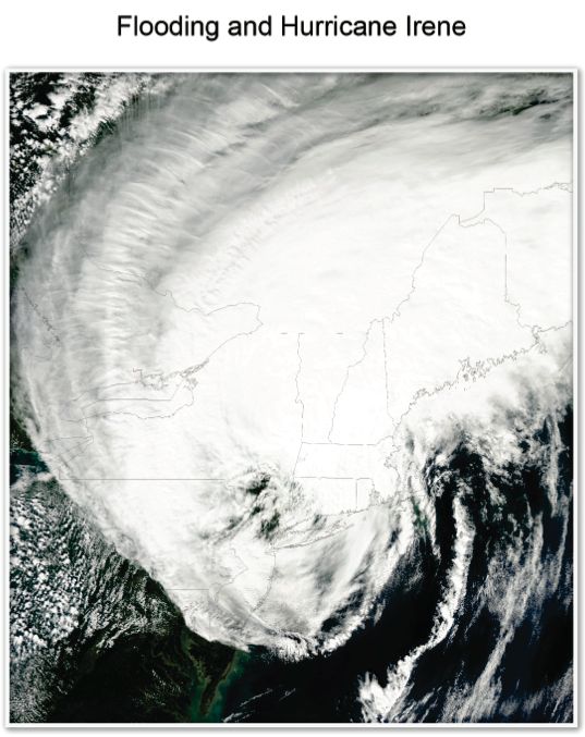
Hurricane Irene brought a broad swath of very heavy rain (greater than five inches in total and 2 to 3 inches per hour in some locations), producing severe flooding from southern Maryland to northern Vermont from August 27 to 29, 2011. Satellite image shows Irene over the Northeast on August 28, 2012. The storm also took approximately 50 lives, and the economic cost was estimated to be approximately $15 8 billion (Avila and Cangliosi 2011; Avila and Stewart 2012). (Source: NASA Satellite Image)
- Hurricanes such as Irene and Sandy provided a “teachable moment” by demonstrating the region’s vulnerability to extreme weather events and the efficacy of existing and evolving adaptation/response plans. ~~~ Northeast Assessment, Federal Advisory Committee Draft Climate Assessment Report – January 2013
- The “Frankenstorm” should be a teachable moment to show how “extreme weather” and lax regulations of greenhouse gas emissions and coastal over-development have put thousands of people and billions of dollars of property in harms way. … The storm should be a clarion call for finally addressing the rising global warming crisis. (Bill Wolfe, 10/26/12)
The Federal Advisory Commitee released a Draft Climate Assessment Report for public comment (the comment period closes April 12, 2013))
Here is a link to the webpage, which includes the Full Report (huge file).
Here is the Executive Summary and Here is the Northeast States. I excerpted some NJ stuff below:

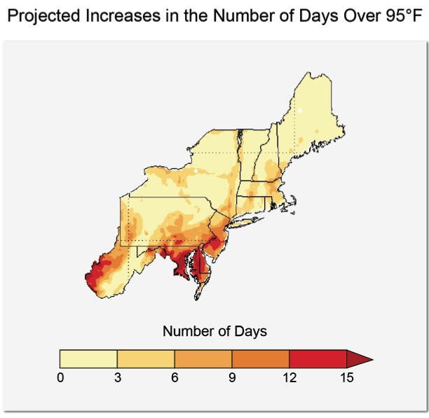
Projected average increases in the number of days with a maximum temperature greater than 95°F between 2041-2070, compared to 1971-2000 assuming continued increases in global emissions (A2 scenario). (Figure source: NOAA NCDC / CICS-NC. Data from CMIP3 Daily Multi-model Mean.)
Much of the southern portion of the region, including the majority of Maryland, and Delaware, and southwest West Virginia and New Jersey, are projected to experience more than 15 additional days per year above 95°F, which will impact the regions vulnerable populations infrastructure, and agriculture and ecosystems.
- Heat waves, coastal flooding due to sea level rise, and river flooding due to more extreme precipitation events will pose a growing challenge to the region’s environmental, social, and economic systems. This will increase the vulnerability of the region’s residents, especially populations that are already most disadvantaged.
- Infrastructure will be increasingly compromised by climate-related hazards including sea level rise and coastal flooding, and intense precipitation events.
- Agriculture and ecosystems will be increasingly stressed by climate-related hazards, including higher temperatures, sea level rise and coastal flooding, and more extreme precipitation events. A longer growing season may allow farmers to explore new crop options, but this and other adaptations will not be cost or risk-free, and inequities exist in the capacity for adaptation.
- While a majority of states and several municipalities have begun to incorporate the risk of climate change into their planning activities, implementation of adaptation measures is still at early stages.