NJ Media Continues To Mislead The Public About Shore Risks
Goundhog Day On Denial of Shore Vulnerability and Climate Change Risks
Many Media Reports Distorted, Scientists Horrified by Coverage
[Important Updates below]
Now that another extreme weather coastal storm has subsided and people have dug out and are returning to normalcy, the press predictably begins to try to explain the situation.
Following what is now an entrenched pattern, the same suspects come out to spin the story, most notably Gov. Christie, who touts his leadership and “model” response – egregious lies the media swallows whole cloth and transcribes, with no independent assessment or critical pushback or alternative plans.
Following the pattern, after the first round of political spin coverage, the press then move on to consult with the “experts” to assure everyone that things are fine, no big deal, don’t worry about that climate thing – and again turns to the same old cheerleaders.
They never print an expert who will tell the truth – that Christie’s shore recovery plan is a boondoggle and a proven failure.
A classic example of that is today’s Bergen Record story – and the story is as misleading as the spun headline:
The story was contradicted by the photo that ran with it. Readers that want truth not spin should visit the Press of Atlantic City’s coverage and photo gallery – or even the North Wildwood Police Department’s twitter feed, who posted some great pics.
The Record’s story was so bad, it prompted this note to the Record reporters who wrote it:
Hi – unfortunately, you buried the lead in the closing quote and misled readers – again.
Ask Prof. Farrell, who is NJ’s biggest cheerleader for beach replenishment and dunes, if they do anything to protect back bay flooding risks.
Rutgers professor Mike Kennish has called back bay flooding the “achilles heel” of the whole recovery plan.
Do an experiment: Take a look at a map, then count the buildings along the 128 mile shoreline. Call this group A.
Then count the buildings along thousands of miles of back bay shoreline. Call this group B
The far smaller Group A gets BILLIONS of dollars of ineffective protection.
The much larger Group B gets ZILCH.
Does that make sense? That’s the story.
Plus, the Christie DEP is rolling back flooding and coastal zone regulations, which have triggered opposition by EPA, FEMA and the NJ League of Municipalities – the NJ Legislaure just exercised Constitutional power to veto these DEP rules.
Amazingly, the Record has not reported on any of that. Why?
Update – my apologies to Tom Moran, who gets it right.
But while Moran gets the big picture right, he made an important mistake by crediting Christie DEP with the 1 foot elevation standard. Moran wrote:
“The coastal states near us — New York, Delaware and Maryland – all set stricter building standards after Sandy, requiring elevations two-feet above the outdated federal limits. Scientists at Rutgers University urged Christie to do the same. But he set the limit at one-foot above.”
Moran correctly criticizes that 1 foot standard as ineffective and insufficient, but he got it wrong. Moran’s error implies that Christie actually learned something from Sandy and strengthened regulations based on climate risks (sea level rise) when in truth he did not. (Christie is actually weakening flood rules)
The 1 foot “freeboard” standard was adopted way back in 2007 by the Corzine DEP.
… here are the facts … regarding the history of the 1 foot elevation standard, in DEP’s own words:
The Department recognizes that sea level rise is a concern and will continue to evaluate necessary measures to address the effects of sea level rise. The Department promulgated new Flood Hazard Area Control Act rules, N.J.A.C. 7:13, in November 2007. These rules require new structures, roadways, and parking areas to be elevated 1 foot above the regulatory flood elevation. Under the rules, the Department exerts jurisdiction over tidally flooded areas and therefore this standard applies in areas subject to tidal flooding. The elevation requirement provides a safeguard against the potential effects of sea level rise. (@ p. 57)
And here it is again, in a different DEP regulatory document:
RESPONSE: The Department acknowledges that sea levels may rise in the future.However, there is no agreement in the scientific community regarding how quickly or by how much sea levels will rise. The requirements for new buildings to be set back from the top of bank and to have a lowest floor at least one foot above the flood hazard area design flood elevation will provide some protection against a sea level rise for these structures. In absence of conclusive data on which to base substantive standards, the Department believes that general permit 7 will adequately provide for the protection of the environment and the public safety, health and general welfare. If sea levels do indeed rise in the future, this will have the effect of raising the flood hazard area design flood elevation for future construction. (@ p. 359)
Update #2 – here’s another example from NJ.com – see the photo caption – those are piles of sand, not dunes. Note new construction in harms way. Story ignores all that.
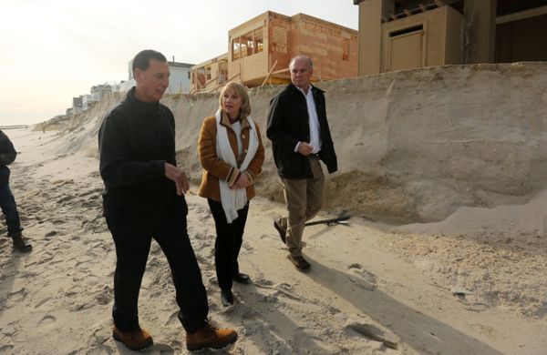
Lt. Governor Kim Guadagno walks with Rep Frank LoBiondo, left, and state DEP Commissioner Bob Martin past the eroded dunes of Long Beach Twp as she tours blizzard storm damage. 1/25/16 Long Beach Twp, NJ (John Munson | NJ Advance Media for NJ.com)
Update #3 – 1/26/16 – We rarely agree on politics, but Mulshine get it exactly right:
In Margate there was indeed some flooding on the streets. But the water came from the bay, not from the ocean. The town’s refusal to sign on to the sand-replenishment project had nothing to do with it, said Mayor MichaeI Becker.
When I called him yesterday he described watching that press conference on TV.
“He’s showing an old picture of water coming over the bay, where it comes all the time, and he’s saying Margate’s flooding,” Becker said. “All the flooding we got came from the bay.”
This was no surprise, he said. Beach towns in Atlantic and Cape May counties routinely flood when bay levels rise. Yet the town got no response when it applied for a grant to beef up bulkheading on the bayfront, Becker said.
BINGO!