Bear Canyon, Coronado National Forest – Miller Peak Wilderness
[Updates below]
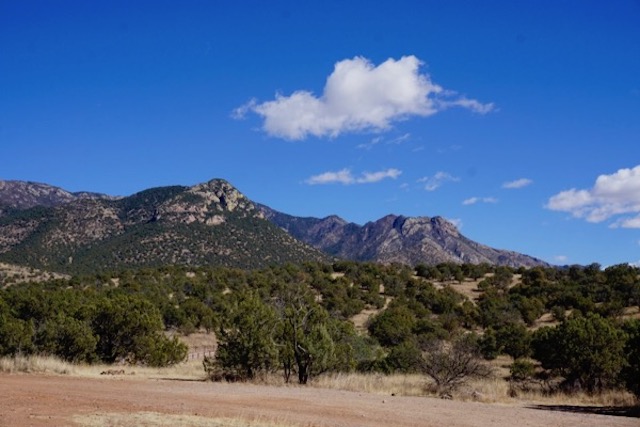
I’ve spent the last week basically looking at that lovely mountain range (photo above) and exploring cool desert canyons, while camping in a place called Bear Canyon, just about 6 miles southwest of Montezuma’s Pass in Coronado National Forest, Arizona.
I also managed an exhausting hike up a spectacular canyon below Miller Peak, part of Miller Peak Wilderness. I was heading back into town after a week in Bear Canyon when I noticed a USFS trailhead sign along FS Road #61. So, I parked and hiked in. After about 2 miles and 500 feet of elevation gain, in a bowl surrounded on three sides by 1,000 foot cliffs, I finally came to the trailhead. After another half mile, I hit the wilderness boundary. Shortly thereafter I saw the trail sign which said “Miller Peak 6 miles” (and at least another 1,500 feet elevation!). Tired, with no water or food, I sat down for a rest and then reluctantly headed back to the van. But, on the way back, we had a fun surprise: we found an old miner’s tin shack.
Bear Canyon was one of only 2 canyon’s I’ve hiked or driven across in hundreds of square miles of desert that had a flowing creek, so I wanted to explore it. I assume the creek is called Bear Canyon Creek.
I immediately came across a sign about a Bear Canyon Watershed Restoration Project by US Forest Service and Arizona Game and Fish.
Just below the sign were a series of spectacular cold deep pools carved out of the rock –
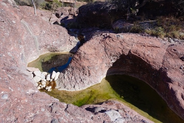
The water was cold – must be great in summer desert heat, but way too cold to take a plunge on a mild winter day. Since it hadn’t rained or snowed in a long time, I assumed the creek’s base flow was from groundwater.
[Note – not sure that assumption is valid. Now reading this US FWS study of the headwaters of the Sant Cruz River. Confused by terminology – never heard of a “tinaja”:
Beyond the old dam at Sycamore Reservoir, Bear Canyon narrows to a bedrock canyon and there is sporadic perennial water located in pools created by depressions in the bedrock. These tinajas are created and destroyed due to the large amount of sediment that continues to move through the drainage as a result of the 2003 Aspen fire. (at page 10-65) ~~~ end Note]
But upon closer look I noticed tons of algae – everywhere! Damn, way out here in the wild Arizona desert, there are streams that look like they are suffering more severe eutrophication (impairment) than in densely populated NJ! Look:

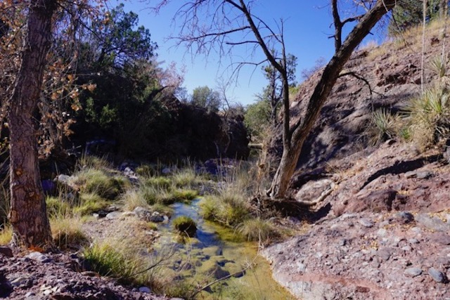
So, I hiked upstream to see if I could find the source of the nutrient problem. I didn’t have to go far to see all the cow pies and cattle grazing along the canyon’s hillsides.
[Note: I know virtually nothing about western desert stream ecology. Reading this paper now – BIOGEOCHEMISTRY OF NITROGEN IN SONORAN DESERT STREAMS – apparently, desert streams are nitrogen limited (eastern are phosphorus) and there are natural and atmospheric sources of nitrogen in addition to cattle.]
Cattle grazing was destroying the water quality in the creek – and likely lots of native vegetation, while causing erosion too.
[Note: there’s good research to learn from, see this on the Sonoran desert (located northwest of Coronado, which is in the Chihuanhuan desert):
THE IMPACTS OF LIVESTOCK GRAZING IN THE SONORAN DESERT: A LITERATURE REVIEW AND SYNTHESIS and this general overview by the Center for Biological Diversity ~~~ end Note]
So, when I got back into town and library (been staying mostly in funky Bisbee “Like Mayberry On Acid” is the local bumpersticker) I looked into the Watershed Restoration Project and noted that it didn’t even mention water quality or severe damage from grazing. Here are the goals of that project:
The project has three goals, to remove ecologically detrimental non-native invasive plants, to increase native plant diversity to benefit wildlife and pollinators, and to protect work which has been completed downstream on private land to enhance watershed function. As a result, wildfire risk will be reduced and wildlife habitats improved.
Sounds like NJ Audubon style work and DEP fish and game engineering!
By far the most scarce, ecologically and economically valuable, and threatened natural resource in the west is water. It is incomprehensible that a watershed restoration plan fails to include water resource protection.
Sounds like the same sounds like science “restoration” scams parading under pretty slogans like “stewardship” and “riparian mitigation” and “watershed planning” in New Jersey! Could there possible be as corrupt mendacity and dealmaking?
US Forest Service and Arizona Game and Fish probably rely on pliable “conservation” “partners”, just like they do in NJ too!
Here’s how USFWS describes things:
The project will be an addition to accomplishments of the Sky Island Restoration Cooperative, a bi-national community-based collaboration of government and non-governmental organizations, private landowners, ranchers, students, volunteers, scientists and restoration practitioners, of which the Coronado National Forest is a contributing member and a beneficiary of work completed on Forest land.
Real watershed restoration would: 1) end grazing and get the the cattle out of the watershed, 2) remove thousands of cow pies, 3) remove water diversion to supply the (at least 10,000 gallon?) water storage tank to serve cattle in the headwaters, and 4) close the road to motorized vehicles.
At only 10-20 inches of precipitation annually, it will take a LONG time to naturally flush all those nutrients out of the watershed.
But you’ll never get those kinds of restoration projects with the “partners” in charge.
[Update: Wow. I thought NJ’s Passaic River was bad in terms of dominance of flow of wastewater discharge.
But check out the Santa Cruz River – the USFWS Report (p. 10-65) cavalierly finds an egregious violation of the Clean Water Act (existing and designed uses must be maintained).
Perennial flow is provided by several municipal wastewater treatment plant outflow pipes at Sweetwater and Roger Roads. This portion of the river is perennial due to discharges of treated effluent from several treatment plants located along the river. This treated effluent’s water quality is very poor for aquatic species survival due to high levels of ammonia and low levels of dissolved oxygen (Pima County 2002; Walker et al undated).
How did they get away with avoiding upgrades to those POTW permits? Where the hell are EPA and Arizona DEP water quality people?