Landscape Project Under Siege
Governor Christie’s Environmental Protection Transition Report called for the elimination of the Landscape Project map .
That and other recommendations would be a huge setback for protection of threatened and endangered species habitat and ecosystem protection. Here is the Report recommendation (note the use of the word “purported”, which attacks DEP science):
Immediately suspend the inappropriate use of the Landscape Project mapping of purported Threatened and Endangered species habitat.
DEP Commissioner Bob Martin agreed with that specific recommendation during his Confirmation hearing on Monday. He claimed that the Landscape Project Map was being inappropriately used for regulatory purposes and that it must be abandoned and replaced by a non-regulatory alternative.
Today, the Endangered and Non Game Species Advisory Committee met to discuss, among other things, the Landscape Project and “Transition Issues“.
The Landscape Project has enormous potential and is a cutting edge GIS tool. It needs to be strengthened and more effectively implemented. Protection of T&E (including rare and critical ecosystems) and mapped habitat needs to be made mandatory in DEP water resource and land use permit regulatory programs, and also authorized as a basis for local land use Master planning and zoning decisions under the Municipal Land Use Law. But the Christie/Martin move is exactly the OPPOSITE and instead would weaken protections. According to DEP:
The Landscape Project is a pro-active, ecosystem-level approach for the long-term protection of imperiled species and their important habitats in New Jersey. The project began in 1994 by the N.J. Division of Fish Wildlife’s Endangered and Nongame Species Program (ENSP). It’s goal: to protect New Jersey’s biological diversity by maintaining and enhancing imperiled wildlife populations within healthy, functioning ecosystems.
The Landscape Project focuses on large land areas called “landscape regions” that are ecologically similar with regard to their plant and animal communities (Figure 1). Using an extensive database that combines imperiled and priority species location information with land-use/land-cover data, the Endangered and Nongame Species Program has identified and mapped areas of critical importance for imperiled species within each landscape region.
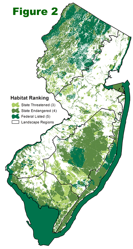
Landscape Project critical habitat maps (Figure 2) were developed to provide users with peer-reviewed,scientifically-sound information that is easily accessible via the internet and hard copy (paper maps). Critical habitat maps were designed for use by anyone, but especially those individuals and agencies who have the responsibility for making land-use decisions, i.e., municipal and county planners and local planning boards, state agencies, natural resource and lands managers, the general public, etc.
Critical area maps can be integrated with planning and protection programs at every level of government – state, county and municipal, can provide the basis for proactive planning, zoning and land acquisition projects.
Most importantly, the critical information Landscape Project products provide can be used for planning purposes before any actions, such as proposed development, resource extraction (such as timber harvests) or conservation measures, occur. Proper planning with accurate, legally and scientifically sound information will result in less conflict. Less time will be wasted, and less money spent, attempting to resolve endangered and threatened species issues.