DEP Statements On Bulls Island Are Flat Out False
DEP Lies and Attacks The Messenger
D&R Canal Dredge Distinct from Bulldozing Riverfront
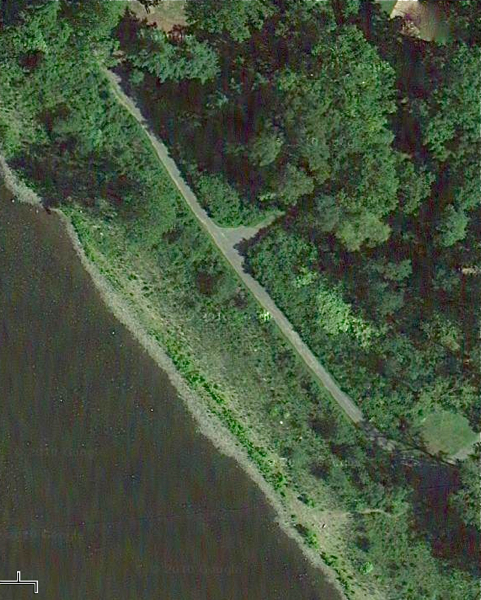
Bulls Island along Delaware riverfront – over 300 feet of vegetation between the river and the paved trail segment was bulldozed and debris was buried in violation of DEP flood hazard (stream encroachment) regulations
The DEP press office lied and attacked me in a Hunterdon County Democrat March 15 story. This post exposes those lies.
The aerial photo above is a portion of Bulls Island along the Delaware River. This area is located entirely within the regulated flood hazard area.
Over 300 feet of this vegetated area between the river and the paved path (you can see above) was bulldozed.
The bulldozing destroyed the vegetation that was present (you can see above) – small trees and other plants.
The bulldozing also disturbed soil and buried a lot of debris. Things like tires were buried and covered up, not cleaned up. Here, take a ground level look (taken on 3/21) and note the small trees that were bulldozed:
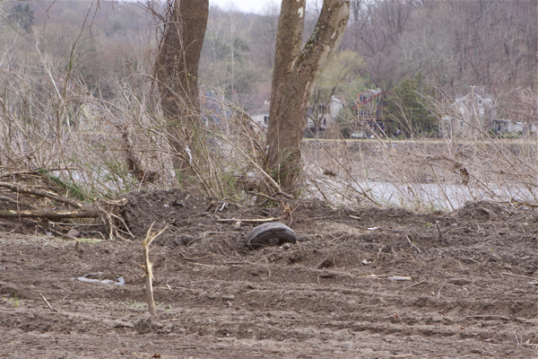
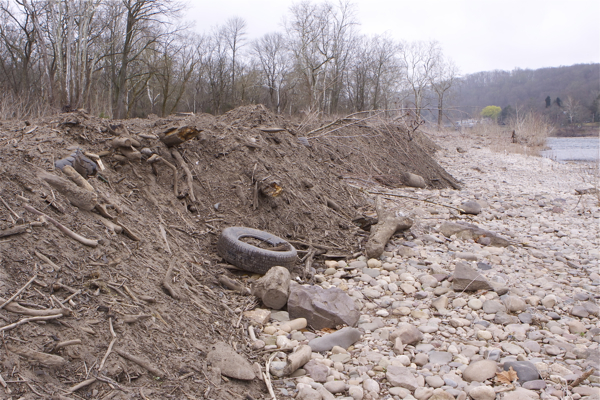
Bulldozing debris, destruction of vegetation, and disturbance of soils in this area is a “regulated activity” in a “regulated area” that requires permits under DEP flood hazard regulations, and possibly DEP freshwater wetlands and local soil erosion and sediment control regulations.
I visited the site, saw this for myself, and have provided several ground level photographs to document this problem, see photos taken on March 10 and again on March 21. If you are not able  to hit the links, here’s another ground level shot (taken on 3/21) of destruction of vegetation, and soil and debris virtually in the river:
In contrast, the aerial photo below is of the northern tip of Bulls Island where the Delaware River flows into the D&R Canal.
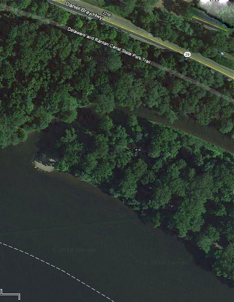
Delaware River flows into D&R Canal at northern tip of Bulls inland State Park. A canal dredging project is being conduced there.
The NJ Water Supply Authority (NJWSA) is dredging a portion of the D&R Canal from the northern tip of Bulls Island about 3,000 feet south. This dredging is being conducted under a US Army Corps of Engineers permit. Here is what that project looks like (taken on 3/21):
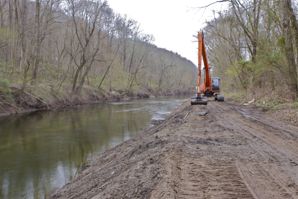
The riverfront bulldozing and the D&R Canal dredging are entirely DIFFERENT projects in DIFFERENT locations subject to DIFFERENT regulations, DIFFERENT technical requirements and with DIFFERENT impacts.
But the DEP Press Office either does not know the difference between the two projects or they are intentionally lying about them. Either possibility is totally unacceptable.
Flood plains and riverfront vegetation and soils are some of the most environmentally sensitive features and heavily regulated areas.
For example, here are the purposes of DEP flood hazard regulations (NJAC 7:13-1.1(c):
- Healthy vegetation adjacent to surface waters is essential for maintaining bank stability and water quality. The indiscriminate disturbance of such vegetation destabilizes the banks of channels and other surface waters, which leads to increased erosion and sedimentation that exacerbates the intensity and frequency of flooding. The loss of vegetation adjacent to surface waters also reduces filtration of stormwater runoff and thus degrades the quality of these waters. Such impacts adversely affect the health and habitat of fish and wildlife that depend upon clean surface waters and therefore disrupt the ecological balance that is necessary for life. Humans are ultimately affected by this imbalance, since clean water is essential for all life.
Because vegetation and soils along stream and rivers are so important, here is what DEP regulations require (NJAC 7:13-2.1:)
No person shall engage in a regulated activity in a regulated area without a flood hazard area permit as required by this chapter, or a coastal permit as required by N.J.A.C. 7:7 and 7:7E, as set forth in (b) and (c) below. Initiation of a regulated activity in a regulated area without a flood hazard area or coastal permit as set forth at (b) below (except as provided in (c) below) shall be considered a violation of this chapter and shall subject the party or parties responsible for the regulated activity to enforcement action, as set forth at N.J.A.C. 7:13-19. Regulated areas are set forth at N.J.A.C. 7:13-2.3 and regulated activities are set forth at N.J.A.C. 7:13-2.4.
Here is the definition of “regulated activity” (NJAC 7:13-2.4):
7:13-2.4 Regulated activities
(a) Any action that includes or results in one or more of the following constitutes a regulated activity under this chapter if undertaken in a regulated area, as described at N.J.A.C. 7:13-2.3:
- The alteration of topography through excavation, grading and/or placement of fill;
- The clearing, cutting and/or removal of vegetation in a riparian zone;
- The creation of impervious surface;
- The storage of unsecured material;
- The construction, reconstruction and/or enlargement of a structure; and
- The conversion of a building into a private residence or a public building.
Seemingly ignorant of their own regulatory requirements, here is what the DEP Press Office told the Hunterdon County Democrat in a March 15 story (the article is reprinted in its entirely below).
As you can see, because the riverfront bulldozing has nothing to do with the D&R Canal dredging, these remarks are incomplete, false, and mislead the public into thinking that the riverfront bulldozing either did not occur or is a permitted part of the D&R Canal dredging:
DELAWARE TWP. – The piles of debris including tires and other materials at Bulls Island State Park are a result of routine maintenance dredging of the Delaware and Raritan Canal, a spokesman for the state Department of Environmental Protection said today, Thursday.“This is an environmentally positive effort,” Larry Ragonese said, rather than the desecration described by environmental activist Bill Wolfe of West Amwell Township in an article published on NJ.com on Wednesday.
The park, along the Delaware River, is mostly in Delaware Township, with the northern portion in Kingwood Township.
“What looked like fill material was being bulldozed along about 400 feet of the floodplain. It was full of solid waste: tires, metal, bottles and cans, chunks of steel and construction debris, wood, and PVC pipe,” he said.
According to Ragonese, the state Water Supply Authority is doing the work, and it has “permits from the DEP and the Army Corps of Engineers.” The authority has responsibility for various public water supplies, including that carried in the canal.
The cleanup “is a permitted action that is being done to improve the health of the canal,” he added.
Ragonese called Wolfe “completely ridiculous and irresponsible” for his comments. Debris is removed from the canal annually, “to keep in flowing and healthy,” Ragonese said.
The materials piled up along the bank is more than normal, he said, because of the big rain storms last year that carried more into the canal.
The soil will be re-used, he said, while the other items will be gone through and separated, recycling what’s possible and disposing of the rest properly, he said. (emphases mine)
Here are a few facts that contradict DEP’s statements. Larry Ragonese should get out of the office a little more or at least do The Google Maps before he shoots off his mouth:
- The tires and debris along the river did not come from the D&R Canal dredging;
- I never used the word “desecration” to describe what was going on at Bulls Island (see my March 10 post). That is someone else’s word, not mine;
- The bulldozing of soils, destruction of vegetation, and burying of debris are environmentally destructive efforts that have nothing to do with the benefits of D&R Canal dredging and maintenance.
- I contacted the US Army Corps of Engineers on March 23 and brought this matter to their attention. I soon will obtain the US Army Corps dredge permit. But I spoke with staff and I strongly doubt that the Army Corps permit authorizes or has ANYTHING TO DO with the the riverfront bulldozing.
- I wrote a letter to DEP Commissioner Martin on March 10 to bring this matter to his attention and ask him what was going on there. I again contacted Martin on March 15 to followup. These efforts on my part are what led to the DEP’s March 15 press release, which advised the public of the campground closing. This is responsible behavior on my part and the DEP Press Office is both lying and engaging in personal attacks by claiming I was “ridiculous and irresponsible”.
- I brought this issue to the attention of the D&R Canal Commission on March 21. The Executive Director and DEP staff to the Commission conducted a inspection on March 23.
- I filed OPRA requests for any DEP permits issued.
- On March 23, I contacted the DEP Hotline and enforcement staff and filed a complaint requesting that DEP conduct a site inspection and take enforcement action.
- Because the D&R Canal Executive Director and DEP staff inspected the site on Friday (3/23/12), I soon will have their inspection report as well.
- On March 23, I spoke to Terry Wright, the Hunterdon County Democrat reporter and left a message on the tape of his editor complaining about their March 15 story. I also emailed Larry Rangonese to provide the above information. Wright defended his false and misleading story, accused me of misleading his newspaper, and asked questions about who I worked for and who funded my work. Rangonese replied, never addressed one substantive issue, and attacked me for criticizing DEP managers.
Full transparency: I plan to take these documents to the DEP Press Office and the Hunterdon County Democrat and demand a retraction of false statements and personal attacks on me that the Democrat recklessly printed without contacting me and providing me the opportunity to rebut or clarify the situation.
We’ll keep you posted as things develop.
Hi Bill, I’m reading and reading and trying to follow the plot line here but the folks at the NJ Department of Environmental Perception keep throwing me off. I reread this post hoping that I would see someone state the purpose for the large disturbance along the river and deposition of the dirty, debris-strewn fill (and say, don’t all the references in the regs, when speaking of fill, esp. near the water, say “clean fill,” and, of course, it has to be for a permitted purpose/disturbance.).
Keep digging to see what they’re up to along the river and where all that debris filled soil came from. You might want to see what the permits say about the quality of the dredge from the canal work and what the specs say the contractors were to do with it, maybe depending on its toxicity level…I don’t think it would be very prudent to just assume that what one dredges from the bottom of canal, even one which has drinking water supply as a purpose, is therefore clean automatically…
Bill: You ere in thinking that this administration actually cares about the existing rules. To date this administration is entirely set on ‘setting aside’ regulations that protect the environment. If it doesn’t suit them or the situation – ignore the regulations or put someone in charge that has no idea what the regulations are. Previously, fill was fill – it didn’t matter if it came from the canal or was from channel deepening. Any artificial placement of material is considered fill and must be considered such prior to its placement. There’s reams of regulations on the beneficial reuse of dredge material just so it doesn’t get put in the wrong place, during the wrong season, and does not have contaminants in it. So – the recent floods have undermined the root systems of old trees so the answer is to remove the trees; the answer to disposal of canal dredge material is to broadcast/spread it along and in the Delaware River so that the next time there’s a flood it all ends up downstream….that makes sense. NOT.
The D&R Canal Commission was no help; how about DRBC that has responsibility for water quality and flood control? Has the ACOE weighed in?
I’m going to throw in a comment on the access fees (to the Del. River) – they are outrageous (I probably already used that term). While everyone is focused on the really bad public access rules for the tidal portion of the state they sneak in these access fees in the non tidal portion of the state, on state land probably purchased with Green Acres (public) funds to state waters. All under the guise of ‘sustainable parks’. Now, won’t towns under the Public Access Rules say “Gee, the state charges for access, why shouldn’t we.” We’re likely to see access fees everywhere, even when Green Acres and public funds have been used for the acquisition. Not to say anything about the damage to vegetation and shoreline and illegal or unsafe parking for people trying to access the waterfront where they don’t have to pay a fee.
I’m sorry – this administration has ZERO environmental ethic. We may be doomed.
Hey Bill the State never seem to stop playing hide and seek have you got the phoney waivers yet?
I am disgusted by the situation at Bulls Island!! This is my family’s favorite spot to camp in NJ – I’ve slept many a night only steps away from where that gross pile of dirt and rubbish is covering the rocks along the river. I could understand, after last year’s tragedy, that they want to inspect all of the trees on the island to prevent another tragedy. And even though I’m bummed I won’t be able to camp there this summer, hopefully they’ll atleast be able to open the main camping area again soon (w/o having to cut down all the trees to deem it safe!) But this crap that is piled along the river really is unexcusable. Keep doing your digging and let us know what you find out!
@Harry Schwartz
Thanks Harry – I agree with your sentiments entirely.
I will post an update tomorrow –
For the dredge project, I’ve reviewed the USACE permit and an expired DEP wetlands permit.
I submitted detailed comments to USACE on that permit and copied all involved.
There are numerous violation of both USACE and DEP permits, in terms of seasonal restrictions to protect wood turtle and trout and disposal of dredge and debris.
As far as I know, there were no permits for the riverfront debacle.
DEP Land Use enforcement has concerns and so does the D&R Canal Commission, but I do not yet have their field reports and enforcement actions.
I also filed an OPRA that DEP has another week to respond to. I am especially interested in the tree health assessment and tree removal plans.
USACE enforcement and the DRBC are aware and active as well.
We’ll keep you posted.
Any update Bill?
@Ed Meakem
soon – documents are still coming in!
Thanks Bill