Is NJ Losing Or Gaining Farmland?
Rutgers Land Use/Land Cover Data Show Significant Continued Loss Of Farmland
NJ Dept. Of Agriculture Claims NJ Has 40% More Land In Agriculture Than Rutgers
NJ Spotlight Claims NJ Is Gaining Farmland
What Explains This Gross Conflict In Data And Trends?
[Update below]
NJ Spotlight’s often misleading number of the day – 9,900 farms – caught my eye, particularly the counter-intuitive claim that NJ is not losing farmland, but actually gaining it:
Agricultural acreage declined significantly between 1978 and 2012, though the USDA’s 2017 Census of Agriculture noted a surprising increase of almost 3%. Today, there are 9,900 farms in the state, covering more than 750,000 acres.
As is typical, the NJ Spotlight shoddy and misleading reporting was prompted by and is based on unverified claims made in a recent NJ Department of Agriculture press release:
New Jersey’s 9,900 farms cover more than 750,000 acres and generate cash receipts of more than $1.1 billion each year.
That NJ Dept. Of Ag. data is roughly consistent with and likely based on the US Department of Agriculture data NJ Spotlight cited, which shows NJ has 734,084 acres of farmland in the most recent USDA 2017 census.
But in contrast, Rutgers land use/land cover data shows only 543,504 acres in agriculture in 2015:
(read the whole 2020 Report: Changing landscapes in the Garden State: land use change in New Jersey 1986 through 2015
This kind of data is never going to be perfectly consistent, particularly land use/land cover data, which is based on different definitions and measurement methods and timeframes than the economic oriented data reported from USDA and NJ Dept. Ag..
But a huge 40% discrepancy between USDA and NJ Department of Agriculture compared to Rutgers is unusual and raises red flags.
This data is particularly important right now given the land use and policy implications (which is likely why the NJ Dept. of Ag. issued a spun press release and NJ Spotlight transcribed it).
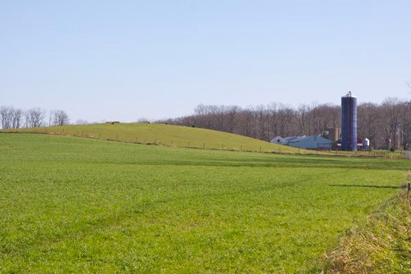
The recent explosion of warehouses, rural development, and solar arrays are consuming the last remaining NJ forests and farmland and the voluntary NJ State Land Use Plan is shown to be “toothless” and “doomed to failure” in preserving what remains of NJ’s vanishing farms and forests.
The same problems emerge when USDA data suggests farmland is not only 40% larger but is increasing in acreage, when Rutgers data show continuing loss of farmland.
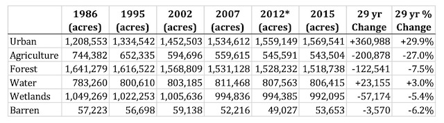
Again, here is Rutgers data, which shows that although the rate of loss has declined, in absolute term, NJ is still losing about 700 acres of farmland per year – and this data is 7 years old, before the current explosion of warehouses, solar arrays and rural sprawl development, so both the net rate of loss and the gross amount of lost farmland is significantly greater:
The net rate of agricultural land conversion has consistently declined from an annualized rate of 10,277 acres per year in T1 (1986‐ 1995) to the most recent 696 acres per year in T5 (2012‐2015). This trend is closely related to the declining amount of farmland consumed by urbanization with 6,114 acres per year in T1, 5,149 in T2, 5,124 acres per year in T3 vs. 1,444 acres per year in T4 to 875 acres per year in T5 (2012‐2015). In addition to conversion of agricultural land to urban land uses, agricultural land continues to be abandoned and allowed to regenerate to forest, a process that has been going on in New Jersey since the peak of agricultural expansion in the mid to late 1800’s. However, this rate continues to decline, with only 341 acres per year in T5 as compared to 1,986 acres per year in T4 vs. 2,435 acres per year in T3.
(Rutgers also reports important data on the declining rate of abandonment of farmland and regeneration of forest, which has serious climate implications as the rate of carbon sequestration and the storage of carbon both decline.)
So, what’s going on? What explains such huge inconsistencies?
I have some suspicions:
1. All this data is far too old to be reliable or to capture the current land development explosion.
Rutgers’s 2020 Report is based on 2015 data. The USDA/NJ Dept. of Ag data is more recent (2017) but also old. USDA updates their data every 5 years. Why can’t Rutgers update their 2020 Report with current data?
2. The USDA census data is based primarily on economic data, not actual land use/land cover data that Rutgers uses.
The economic framework opens up all sorts of misleading data (e.g. the USDA threshold for defining a “farm” is just $1,000 per year in sales) and potential abuses by fake farmers that exploit NJ’s property tax loopholes.
For example, the USDA/Spotlight claim that acreage of farmland increased in 2017 is dubious. This is strong suggested by the fact that 90% of the increase in the # of farms from 2012 – 2017 was farms just 1-9 acre size. I suspect that this data is tainted by “fake farmers” exploiting NJ property tax loophole.
Additionally, USDA data shows that 81% of NJ farms are family/individually owned for tax purposes and 45% of farm sales were less than $2,500/year. This also suggests “fake farmers”.
Accordingly, Rutgers data is more reliable in terms of what’s actually going on on the ground and the USDA/NJDA data reported by NJ Spotlight is highly misleading in terms of the actual acreage in farmland and the rate and amount of farmland lost to development.
Regardless, reform actions must be taken:
- the Rutgers data must be updated,
- the State Planning Act must be amended to put teeth in it
- DEP must act to put teeth in DEP land use regulations,
- environmental groups have to get active
- the media needs to get educated and report reliable data
- Rutgers academics need to speak out publicly
Will someone call Prof. Lathrop at Rutgers and Senator Smith and light a fire under their asses?
[End Note: At least I just tried – see note to Prof. Lathrop and Sen. Smith:
Professor Lathrop – would you care to comment on or explain a 40% discrepancy between USDA Census Of Agriculture and NJ Dept. of Ag. data on NJ farmland versus Rutgers land use/land cover 2020 Report data?
USDA data suggest far larger acreage and a net increase in acreage.
I’d be glad to update my column and print your response – I think this clarification is particularly important in light of current warehouse, solar array and rural developments and recent criticism of the State Plan as “toothless” and “doomed to failure” by former State Plan Commissioner Jim Gilbert (an author of the 1986 State Planning Act).
I wrote about that today, based on what I thought was a misleading blurb by NJ Spotlight, see:
Is NJ Losing Or Gaining Farmland?
http://www.wolfenotes.com/2022/09/is-nj-losing-or-gaining-farmland/
[Update: Prof. Lathrop kindly replied. Here’s his explanation. Not surprisingly, he didn’t bite on the controversial State Plan and land use policy questions I framed, or the need for an update of his 2020 Report:
Hi Bill: the LULC mapping captures areas that are in agricultural land cover/use (i.e., cultivated, orchard, hay or pasture land) or other categories of Ag use like confined feedlots. The USDA and NJDAG is likely including all land area within a farm property/parcel (i.e., under farmland assessment) and that might include woodlots (which wouldn’t be mapped as Ag land in the LULC) or other possible uses. As you point out there is a discrepancy in definitions. I suppose that if more people are enrolling land under farmland assessment, than the Farm area amount might increase somewhat.
Rick Lathrop